Aerial Drone Survey Brisbane

What Can a Drone Inspection Detect?

A drone inspection can document visible condition issues, heat anomalies, access constraints and change over time. It is strongest when a client needs evidence from a roof, facade, solar array, tower, construction site or industrial asset without sending someone into the first point of risk.

The important distinction is this: a drone captures evidence. A qualified specialist interprets defects when the outcome needs engineering, electrical, building or insurance certainty. That distinction protects the client and makes the inspection more useful, because the images can be handed to the right person with clear context.

HexFlix provides aerial inspection services for commercial projects across Brisbane, the Gold Coast, the Sunshine Coast and Australia-wide. Commercial drone work in Australia should be planned around CASA requirements, including drone registration and the right operating approval where the job requires it. CASA also recommends asking a drone operator for proof of registration, licence and insurance before hiring them. See CASA’s guide to hiring a drone operator.
Drone Roof Inspection Finds Visible Evidence Before Access Costs Escalate

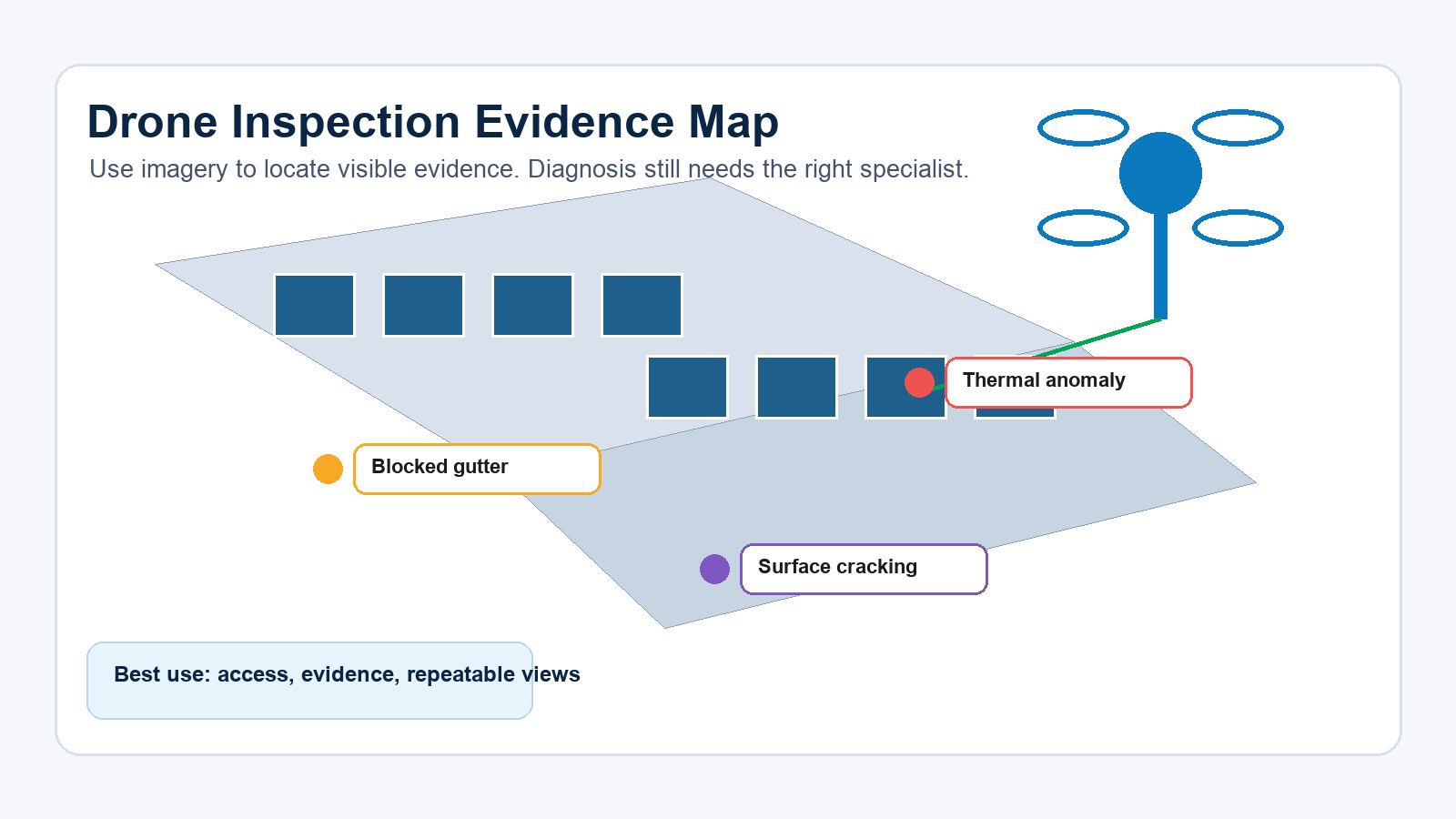
Roof work is where drone inspection often earns its place early. A first pass can show broken roof sheets, lifted flashing, blocked gutters, ponding water, corrosion, cracked ridge capping, damaged skylights, displaced fixings or storm damage. The result is a clearer brief before anyone books scaffolding, rope access or an elevated work platform.

The drone will not confirm the hidden cause of a leak by itself. It can narrow the search area. If a gutter is blocked above the stain line, or a damaged roof sheet sits near the affected room, the maintenance team starts with evidence instead of guesswork.

For Brisbane commercial properties, this matters after storms because multiple sites may need triage. Drone imagery can help decide which assets need urgent physical access and which can wait for scheduled maintenance.

Drone roof inspection also gives asset owners a permanent visual record. That can be useful for maintenance history, insurance conversations, contractor briefing and comparing the same asset after future weather events.

Thermal Drone Inspection Shows Heat Patterns, Not Final Diagnoses

Thermal imaging is useful because some faults show up as temperature differences before they are obvious in normal imagery. On solar assets, thermal images may show hot spots, bypass diode issues, string-level patterns or panels that deserve closer electrical review. On buildings, thermal differences may point to moisture patterns or insulation gaps, depending on the material and site conditions.

Thermal results are sensitive to timing. Solar inspections need suitable sunlight and operating conditions. Building surfaces can be affected by shade, wind, rain, reflections and recent temperature change. A thermal image taken at the wrong time can look technical while saying very little.

This is why a thermal drone inspection should be scoped carefully. The operator needs to know what the client is trying to confirm, what asset is being inspected and who will interpret the findings. If a licensed electrician, engineer or building consultant needs the imagery, the capture should be planned around what that specialist needs to see.

Zoom Drone Inspection Keeps Distance From High-Risk Assets

A zoom camera becomes valuable when the drone should not fly close to the asset. Towers, mast hardware, facade fixtures, signage, roofing edges and industrial equipment often need detail from a controlled standoff distance.

This is not only about image quality. It is about risk. A close flight near wires, cranes, reflective surfaces or people can create avoidable exposure. A zoom lens lets the pilot preserve separation while still capturing bolts, panels, corrosion, missing caps or labels that matter to the maintenance team.

For asset owners, this can also reduce disruption. A zoom inspection can capture detail while keeping the site operating, provided the flight area and risk controls are suitable.

Confined Or GPS-Denied Inspection Needs a Different Plan

Some inspection environments do not suit a standard outdoor drone. Culverts, tunnels, under-bridge sections and indoor industrial spaces may have poor GPS, low light, dust, water, magnetic interference or tight geometry.

If the inspection is indoors or confined, the scope should be checked before the site visit. The operator needs to know the access opening, lighting, airflow, floor condition, radio signal constraints and whether propeller protection or a specialist platform is required.

The useful answer for clients is not “yes, drones can inspect confined spaces”. The useful answer is “only if the environment, aircraft and risk controls match the job”.

What the Client Should Receive After a Drone Inspection

A good inspection deliverable is organised around the asset, not dumped as a camera roll. The client should be able to find the location, compare images and send evidence to the relevant contractor.

Useful deliverables include labelled image folders, high-resolution stills, short video clips, thermal files if captured, annotated screenshots and a short visual summary. For repeat inspections, the capture angles should be planned so future flights can compare the same areas.

For asset managers, this repeatability is often more valuable than a cinematic video. A beautiful flyover may impress stakeholders, but a consistent set of inspection angles helps maintenance decisions.

When a Physical Inspection Is Still Required

Physical inspection is still needed when the surface must be touched, opened, tested or certified. Drone imagery cannot measure material strength, certify electrical compliance, confirm hidden moisture, test fasteners or sign off structural integrity.

The best workflow is often staged. Use the drone to collect the first visual evidence. Use that evidence to brief the trade, engineer, electrician, insurer or asset manager. Then send people only where the evidence says they are needed.

Brisbane Drone Inspection Questions To Ask Before Booking

Ask what asset areas need evidence, what level of detail is required, who will interpret the imagery, what file formats are useful, and whether the site has airspace or access constraints. If the site sits near controlled airspace or requires unusual flight conditions, approvals may affect timing. CASA explains that some operations need flight approvals and permissions.

HexFlix can help scope the capture plan for aerial inspection in Brisbane and supply imagery that supports maintenance, asset review and specialist assessment.

FAQs

Can a drone inspection replace a building inspection?

No. It can support a building inspection by showing hard-to-reach areas, but certification needs the right qualified person.

Can a drone find roof leaks?

It can identify visible roof issues that may relate to leaks. The exact cause may still need physical inspection.

Can thermal drone inspection find solar panel faults?

It can highlight heat patterns that deserve closer review. Electrical diagnosis still needs the right specialist process.

What should be included in a drone inspection report?

At minimum, labelled imagery, asset locations, capture notes and a clear explanation of what the images do and do not confirm.

Is commercial drone inspection legal in Australia?

Yes, provided the operator follows CASA requirements and holds the right registrations, licences or approvals for the job.

Video Production Brisbane

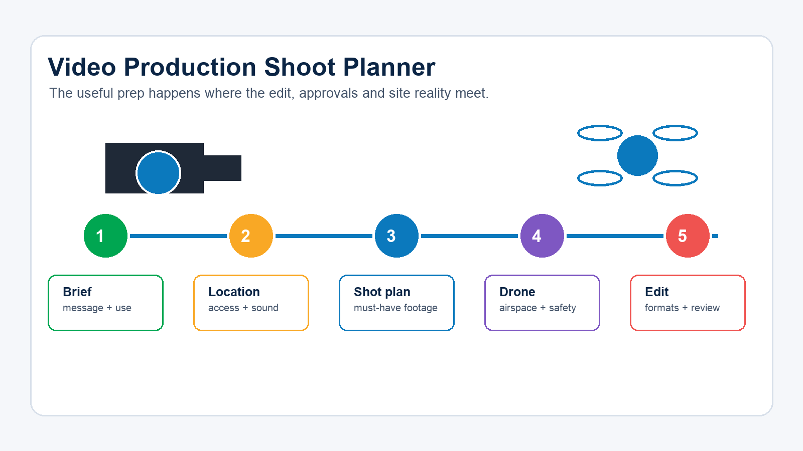
Video Production Shoot Checklist for Brisbane Businesses

Most video shoot problems do not start with the camera. They start with vague approvals, noisy locations, unclear deliverables or a shot list that misses the footage the edit needs.

For Brisbane businesses, the useful preparation is practical. Decide where the video will be used, who has approval authority, what must be captured on the day, what the site will allow, and whether aerial footage changes the plan.

HexFlix provides video production in Brisbane, with supporting aerial video and professional photography when a project needs stills and motion assets from one production day.

Start With the Final Edit, Then Plan the Shoot

The best shoot plan starts with the final deliverable. A homepage brand video, a 30-second social ad, a recruitment profile and a real estate walkthrough all need different footage. If that decision waits until after filming, the editor has to make do with whatever was captured.

Before the shoot, confirm the main video length, where it will be published, aspect ratios, caption needs, cutdown versions and deadline. A website video may need a wide horizontal frame. A paid social campaign may need vertical framing and faster visual changes. A conference screen may need safe margins for text.

This is where many businesses lose time. They plan the shoot as an event, then discover the deliverables require a different set of shots.

The practical fix is simple. Write the export list first. If the project needs one hero video, three social cutdowns and a vertical reel, the camera team can frame for that from the start. If the export list is unknown, the production day becomes harder to protect.

Location Noise Is a Production Issue, Not a Minor Detail

A location can look excellent and still be poor for video. Air conditioning noise, road traffic, echo, forklift movement, nearby construction and reflective glass can all affect the result.

For interview-heavy shoots, check sound before the crew arrives. A quiet boardroom often works better than the most impressive foyer. If filming needs to happen in an active workspace, choose the times when staff movement and machinery noise are lowest.

For outdoor Brisbane shoots, light and weather matter. Midday sun can create harsh shadows. Wind can affect audio. Storm season can change the plan quickly. A practical shoot schedule should include a backup interior shot or weather option.

Location preparation also affects safety and speed. Clear parking, lift access, loading space, site contacts and power access reduce wasted time. If the crew spends the first hour finding the right person or waiting for a door to open, the shoot loses momentum before the first shot.

Approvals Should Be Decided Before Shoot Day

The slowest person on a shoot is often the person who was not told they needed to approve something. If the business owner, marketing manager, property manager or compliance contact needs to sign off content, name that person before the production date.

Approvals can affect signage, uniforms, customer faces, vehicle plates, confidential documents, site access and claims made in interviews. On industrial or construction sites, approvals may also include inductions, PPE, traffic control or restricted areas.

If people appear clearly on camera, confirm consent requirements before filming. If the location is leased, confirm whether the tenant, building manager or landlord needs to approve filming.

A Useful Shot List Is Built Around Proof

Generic shots make generic videos. A better shot list captures proof of the business doing the work.

For a service business, proof might be the crew preparing equipment, the team solving a site problem, the finished result, a client handover or a process that shows care. For a property or construction project, proof might be access, scale, location, progress, before-and-after context or detail shots that show quality.

The shot list should separate must-have footage from nice-to-have footage. Must-have shots protect the edit. Nice-to-have shots add polish if time, weather and access allow.

The useful test is whether the shot answers a viewer question. If a buyer wants to know what the site looks like, show the site. If they want to know how the service works, show the process. If they need confidence in the team, show people doing real work.

Drone Footage Changes the Production Plan

Drone footage is not just another camera angle. It changes the schedule because airspace, weather, take-off points, people, vehicles, trees, powerlines and property permissions all matter.

If the video needs aerial footage, confirm the exact address, required view lines, safest launch area, time of day and any sensitive areas that should not be filmed. For commercial drone work, CASA says business drones must be registered, and operators may need the right accreditation, licence or approvals depending on the job. CASA’s drone registration requirements explain the baseline rules for business use.

Aerial footage works best when it has a purpose. It can establish location, show scale, reveal access, track movement or connect a property to nearby features. Random aerial shots look expensive but may not help the story.

Interview Prep Should Keep People Natural

Most people do not need a script. They need to know the question, the point and the audience. A memorised answer often sounds stiff, while a guided answer can feel more credible.

Give speakers the topic areas before the shoot. Ask them to prepare examples rather than exact wording. The best answers usually mention a real problem, the process used to solve it and what changed for the client.

Avoid unsupported claims. If someone says “we are the best” or “we guarantee”, the editor may need to remove it later. Stronger claims are usually more specific, such as describing licences, process, response time, service area or project experience that can be backed up.

Brand Assets Should Arrive Before Editing Starts

The edit slows down when logos, colours, lower-third names, web addresses or legal lines arrive after the first cut. Send brand files before the shoot or immediately after.

The production team should also know if the final video needs captions, music restrictions, supplied voiceover, client logos, project names, privacy restrictions or usage limitations. These details affect the edit from the first timeline, not only the export.

What To Ask HexFlix Before Booking

Ask what can be captured in one production day, what footage is needed for the final deliverables, whether drone filming is practical at the location, what access constraints may affect the shoot, and what the approval path should look like.

If the project also needs still images, planning photography and video together can save time on site. It also keeps lighting, framing and brand style more consistent.

For commercial projects, contact HexFlix about video production in Brisbane or use the contact page to brief the team.

A Brisbane Video Shoot Brief Should Name the Constraints

A useful video brief does not need to be long. It needs to name the constraints that affect production. Those constraints are usually location access, available people, operating hours, noise, safety requirements, weather exposure, drone permission and approval timing.

For example, a warehouse shoot may need to work around deliveries and forklifts. A construction shoot may need PPE, induction and restricted-area planning. A property shoot may need sunlight, tenant approval and clean access. A corporate interview may need quiet rooms, controlled lighting and enough time for the speaker to settle.

When these details are confirmed early, the production team can spend the day capturing useful footage instead of solving avoidable logistics.

One Shoot Can Create Several Useful Assets

A business video shoot does not need to produce only one finished video. With the right plan, the same production window can capture a website video, short social edits, still images, staff portraits, aerial establishing shots and behind-the-scenes material.

This only works if the deliverables are planned before filming. If vertical social edits are needed, the camera team can protect framing for that. If website stills are needed, the crew can set aside time for clean images rather than pulling frames from video later. If drone footage is needed, the flight can be scheduled around light, wind and site access.

For many Brisbane businesses, this is where production planning creates value. The shoot day is already the expensive part. A clear deliverables list helps the business get more useful assets from the same time on site.

FAQs

What should a business prepare before a video shoot?

Prepare the final deliverables, location access, approval contact, must-have shots, interview speakers, brand assets and any drone requirements.

Do we need a full script?

Not always. Interviews often work better with prepared topics and natural answers. Scripted sections are useful when exact wording matters.

Can drone footage be included?

Yes, when the location, airspace, weather and permissions allow it. Commercial drone filming needs the right operator and planning.

How do we avoid delays on shoot day?

Confirm parking, access, people, approvals, quiet spaces and site restrictions before the crew arrives.

Should we capture photography on the same day?

Often yes. If the setup, people and location are already ready, still photography can create useful web and social assets from the same production window.

LiDAR vs Photogrammetry for Drone Surveying

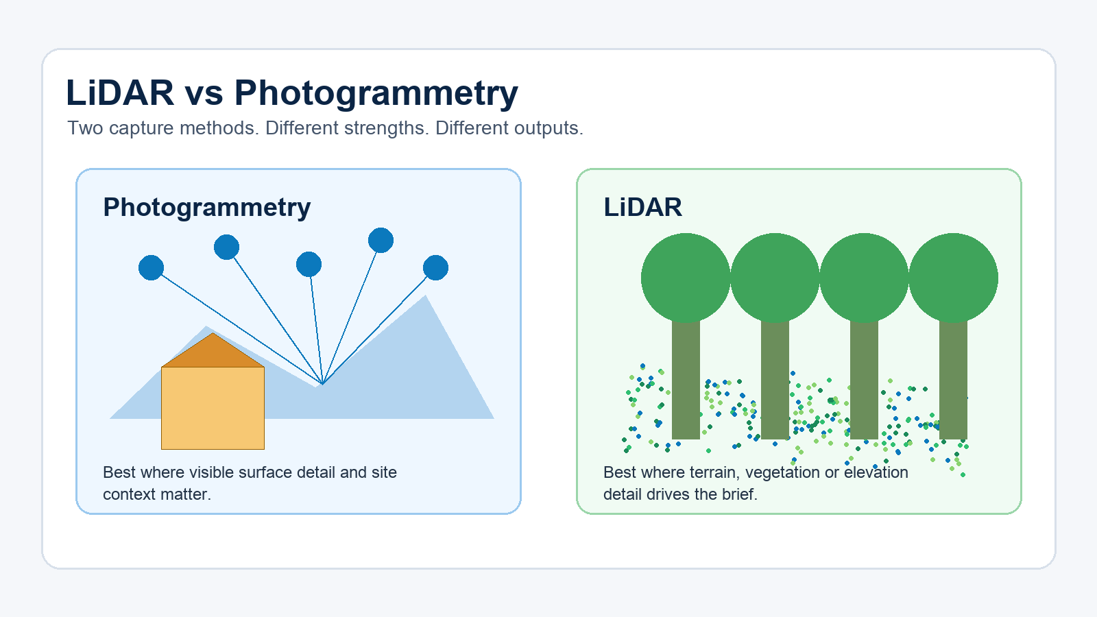
Photogrammetry and LiDAR both create spatial data, but they answer different site questions. Photogrammetry turns overlapping photos into maps and models. LiDAR measures distance with laser pulses and produces a point cloud that can support terrain and elevation work.

If the site is visually open and the client needs an orthomosaic, model, progress record or surface measurement, photogrammetry can be a practical choice. If vegetation, terrain or elevation detail drives the brief, LiDAR may be the better capture method.

HexFlix provides aerial survey services for commercial projects across Brisbane, the Gold Coast, the Sunshine Coast and Australia wide.

When Is Drone Photogrammetry the Better Choice?

Photogrammetry depends on image overlap. The drone captures multiple images from planned positions, then specialised software identifies shared points across those photographs. Depending on the project requirements, the resulting data can be used to produce an orthomosaic, 3D model, digital surface model, contours or volume calculations.

One of the main strengths of photogrammetry is its visual context. A project manager can see the site as well as its geometry. This makes photogrammetry useful for construction progress, roof mapping, stockpile context, facade documentation and site reporting.

Its main limitation is also visual. If the camera cannot see the ground, the model cannot reliably describe the ground. Long grass, tree canopy, shadows, water, reflective surfaces and areas with limited visual texture can reduce the quality or completeness of the resulting model.

Photogrammetry also depends on consistent flight planning. Poor image overlap, changing light, reflective materials or missed capture angles can create gaps in the model. For repeat progress mapping, the flight plan should be reproducible so the client can compare outputs captured at different stages of the project.

When Is Drone LiDAR the Better Choice?

LiDAR uses laser pulses to measure distance. The resulting data is generally produced as a point cloud, which can then support terrain models, elevation products or asset measurements.

LiDAR becomes valuable when the brief is focused more on the shape of the land or structure than on photographic site detail. It may capture returns through gaps in vegetation, which is why it is often considered for vegetated corridors, uneven terrain, infrastructure assets and locations where photogrammetry may only represent the top of the vegetation.

LiDAR cannot automatically overcome every site condition. Dense canopy, unsuitable flight planning, weak control and inappropriate processing can still limit the result. The sensor, capture method and processing workflow all affect the quality of the final data.

The decision should begin with the required output. If the project team needs a visual map for communication or progress reporting, photogrammetry may be sufficient. If the team needs terrain information beneath partial vegetation or detailed elevation data, LiDAR may be worth considering.

How Do LiDAR and Photogrammetry Compare?

Survey question Better starting point Why it matters
Do we need a clear visual map of the site? Photogrammetry An orthomosaic provides strong photographic context.
Do we need ground data beneath partial vegetation? LiDAR Laser returns may capture terrain through gaps in vegetation.
Do stakeholders need clear progress evidence? Photogrammetry Photographs can make site changes easier to understand.
Is elevation detail the main requirement? LiDAR Point clouds can support terrain and elevation products.
Is budget the main constraint? Photogrammetry Camera based capture can often be more economical.
Is the site technically complex? Scope the project first Some projects may require both methods or specialist review.

What Determines Drone Survey Accuracy?

Clients often ask which method is more accurate. A more useful question is what level of accuracy the project requires and how that accuracy will be checked.

Accuracy can be affected by flight height, image overlap, point density, sensor calibration, ground control, RTK or PPK workflows, lighting, wind, surface type and data processing. An advanced drone flown without a suitable plan can produce weak data. A more modest aircraft flown according to a carefully prepared plan can produce useful results for the right brief.

If legal boundaries, cadastral information or formal survey certification are involved, a licensed surveyor may be required. Drone data can support the wider workflow, but the responsibility for reviewing and certifying the information must be clearly established.

The phrase “survey grade” should also be used carefully. It may refer to data suitable for design, asset management or formal cadastral work, depending on who is using the term. These applications do not have identical requirements. The project scope should state the required tolerance, control process and review responsibility.

Why Do Ground Control Points Matter?

Ground control points connect drone data to known locations. They can help align project outputs and improve confidence in the data, particularly when the client requires measurements, repeat surveys or files that will be handed to another consultant.

Some drone workflows use RTK or PPK positioning. These tools may reduce the need for dense ground control, but they do not remove the need for quality checks. For projects where accuracy is important, independent checkpoints can help establish whether the output is suitable for its intended purpose.

Ground control can also improve comparisons between data captured on different dates. If a construction or earthworks site is mapped each month, alignment is important because the client is looking for meaningful change. Weak control may make change detection less reliable.

Which Drone Survey Outputs Should You Request?

Begin with the decision that the data needs to support. If the client needs to brief contractors or communicate project progress, a visual map may be enough. If the project requires terrain information, contours or integration with a design workflow, the required deliverables may include point clouds, GeoTIFF files, contours or CAD compatible files.

A useful drone survey scope should identify the deliverables, coordinate system, file formats, accuracy requirements, coverage area and review process. A vague request for survey grade drone mapping can cause problems because different clients and consultants may interpret that phrase differently.

The people who will use the files should be involved when preparing the brief. This helps confirm that the selected capture method, coordinate system and output format are compatible with the project’s wider workflow.

What Should Be Confirmed for a Brisbane Drone Survey?

Brisbane sites can involve controlled airspace, active construction areas, vegetation, steep terrain, reflective roofs and restricted access. These conditions can affect the selected capture method and whether the required data can be collected during a single site visit.

Before booking a drone survey, confirm the site boundary, required outputs, vegetation level, delivery format, deadline and who will rely on the information. If the output will support engineering, design or legal decisions, establish who will review or approve the data.

For commercial mapping, talk to HexFlix about aerial survey services in Brisbane or submit your project details through the HexFlix contact page.

How Can You Prepare a Better Drone Survey Brief?

Understanding the difference between a visual map, surface model, terrain model and point cloud helps buyers provide clearer project information. A better brief allows the drone operator to assess the site requirements and recommend an appropriate capture method.

The brief should include the site location, required coverage, vegetation conditions, output files, accuracy expectations, deadline and intended use of the data. If a civil consultant, engineer, asset manager or licensed surveyor will use the output, that person should help define the requirements before the flight takes place.

Universal accuracy promises should be treated cautiously. The achievable result depends on the site, equipment, control process and intended deliverables. A defined workflow and clear project scope provide more useful information than an accuracy figure presented without context.

Frequently Asked Questions

Is LiDAR better than photogrammetry?

LiDAR is often better suited to projects involving terrain and vegetation challenges. Photogrammetry is often more suitable when clear visual site context is required. The better method depends on the information the project needs to produce.

Can photogrammetry create contours?

Yes. Photogrammetry can support the creation of contours when the capture and processing methods are suitable. If vegetation hides the ground, the contours may describe the visible surface rather than the true ground level.

Can LiDAR see through trees?

LiDAR may capture some ground returns through gaps in vegetation. It does not see directly through solid vegetation, and dense canopy can still limit the amount of ground information captured.

Do drone surveys need ground control?

Many drone survey workflows benefit from ground control points or independent checkpoints. The requirements depend on the expected accuracy, site conditions, capture method and intended use of the data.

Can drone mapping replace a licensed cadastral survey?

No. Legal boundary and cadastral work must involve the appropriately licensed survey professional. Drone data may support related project work, but it does not automatically replace professional surveying or certification.

Hexflix Aerial Drone Photography and Aerial Drone Video Brisbane

HexFlix 2018 Showreel

HexFlix 2018 Showreel from HexFlix on Vimeo.


The crew at HexFlix have years of experience at the controls and are masters at aerial photography and aerial video. HexFlix are legends in Real Estate Aerial Photography, Real Estate Video, Aerial work for Film and TV, Documentary, Corporate Videos, aswell as providing services in Aerial Surveying, and Aerial Inspection. HexFlix has a flawless safety record conducting Aerial Photography and Video services and works with Australia’s leading companies to deliver outstanding Drone Video and Drone Photography projects.


Brisbane event professional photography hexflix

Hexflix Event Photography